

In 1908, an amateur American geologist named Frank Bursley Taylor thought – rightly – that continents moved and their crashing together could have pushed up the world’s mountains. He noticed that some continents were shaped very similarly to others so that, for example, South America might have been fitted to Africa like a jigsaw puzzle, and so on. He did not produce much evidence though and the theory was considered too crazy for serious attention.
The Earth Moves – Tectonic Plates & Continental Drift
 In 1908, an amateur American geologist named Frank Bursley Taylor
thought – rightly – that continents moved and their crashing together could
have pushed up the world’s mountains. He noticed that some continents were
shaped very similarly to others so that, for example, South America might have been
fitted to Africa like a jigsaw puzzle, and so on. He did not produce much evidence though
and the theory was considered too crazy for serious attention.
In 1908, an amateur American geologist named Frank Bursley Taylor
thought – rightly – that continents moved and their crashing together could
have pushed up the world’s mountains. He noticed that some continents were
shaped very similarly to others so that, for example, South America might have been
fitted to Africa like a jigsaw puzzle, and so on. He did not produce much evidence though
and the theory was considered too crazy for serious attention.
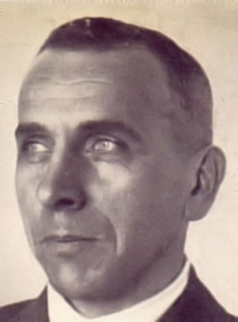
In Germany, however, Taylor’s idea was picked up by a theorist
named Alfred Wegener, a meteorologist at the University of Marburg.
Wegener investigated the many plants and fossils that did not fit comfortably
into the standard
model of Earth history. Animal fossils repeatedly turned up on
opposite sides of oceans that were too wide to swim. How, he wondered, did marsupials
travel from South America to Australia? How did snails turn up in Scandinavia
and the US?
 Wegener developed the theory that the world’s continents had once
come together in a single landmass he called Pangaea, where flora and
fauna
mixed, before the continents split apart and floated to their present positions.
All this he put together in a book, which was published in
German in 1912 and – despite the First World War – in English three
years later.
Wegener developed the theory that the world’s continents had once
come together in a single landmass he called Pangaea, where flora and
fauna
mixed, before the continents split apart and floated to their present positions.
All this he put together in a book, which was published in
German in 1912 and – despite the First World War – in English three
years later.
Wegener’s theory didn’t attract much notice at first, but by 1920,
when he produced an expanded edition, it quickly became a hot talking
point. Everyone agreed that continents moved – but up and down, not sideways.
Clearly the time
was ripe for a new theory. Unfortunately, Alfred Wegener was not the
man that geologists wished to provide it.
For a start, his radical notions questioned the foundations of
geology, not the best way to warm up an audience. This would have been painful
from a geologist, but Wegener had no background in geology. He was a
meteorologist. A weatherman—a German weatherman.
 And so geologists rejected his evidence and belittled his suggestions. To get around the
problems of fossil distribution, they had the idea of ancient ‘land bridges’
wherever they were needed. When an ancient horse was found in France and
Florida at the same time, a land bridge was drawn across the Atlantic. When it
was realized that ancient tapirs had existed simultaneously in South America and
Southeast Asia a land bridge was drawn there, too. Soon maps of prehistoric
seas were almost solid with land bridges. These not only conveniently appeared
when necessary to move a living organism from one landmass to another, but then
vanished
without a trace.
None of this, of course, was supported by actual evidence, yet it was the
religion of geology for the next half century.
And so geologists rejected his evidence and belittled his suggestions. To get around the
problems of fossil distribution, they had the idea of ancient ‘land bridges’
wherever they were needed. When an ancient horse was found in France and
Florida at the same time, a land bridge was drawn across the Atlantic. When it
was realized that ancient tapirs had existed simultaneously in South America and
Southeast Asia a land bridge was drawn there, too. Soon maps of prehistoric
seas were almost solid with land bridges. These not only conveniently appeared
when necessary to move a living organism from one landmass to another, but then
vanished
without a trace.
None of this, of course, was supported by actual evidence, yet it was the
religion of geology for the next half century.
To be sure, Wegener made mistakes. He said that Greenland was drifting west
by about a mile a year, which is nonsense. (It’s more like half an inch.) Above
all, he could offer no explanation for how landmasses moved about. To believe
in his theory you had to accept that massive continents somehow pushed through
solid crust, without leaving any sign of the movement afterwards. What motored
these movements?
 It was Arthur Holmes, the English geologist who discovered the
Earth’s age, who suggested a way. Holmes was the first to understand that
radioactive warming could produce convection currents in the Earth. In theory,
these could be powerful enough to move continents around on the surface. Holmes
suggested a continental drift theory similar to today’s. It was still radical for
the time and widely criticized. However, the new theory also drew steady
if careful support.
It was Arthur Holmes, the English geologist who discovered the
Earth’s age, who suggested a way. Holmes was the first to understand that
radioactive warming could produce convection currents in the Earth. In theory,
these could be powerful enough to move continents around on the surface. Holmes
suggested a continental drift theory similar to today’s. It was still radical for
the time and widely criticized. However, the new theory also drew steady
if careful support.
Interestingly, oil company geologists had known for years that if
you wanted to find oil you had to allow for precisely the sort of surface movements that were
made by plate tectonics. But oil geologists didn’t write academic papers; they
just found oil.
There was another problem with Earth theories no-one had solved.
That was the question of where all the sediment went. Every year, Earth’s rivers carried
massive volumes of eroded material – 500 million tons of calcium, for
instance – to the seas. If you multiplied this rate by the number of years it
had been going on, there should be about twelve miles of sediment on the ocean bottoms – or,
put another way, the ocean bottoms should be well above the ocean tops. Scientists
ignored it.
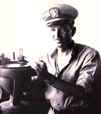 In the Second World War, a Princeton University mineralogist named
Harry Hess was in charge of an attack ship. On this was a new depth sounder,
called a fathometer, which, Hess realized, could equally
well be used for scientific purposes and never switched it off. What he found
was entirely unexpected. If the ocean floors were ancient, as everyone assumed,
they should be covered with sediment, like the mud on the bottom of a river.
But Hess’s readings showed there were canyons, trenches, and volcanoes. All this was odd, but
Hess had a war to fight, and stored such thoughts at the back of his mind.
In the Second World War, a Princeton University mineralogist named
Harry Hess was in charge of an attack ship. On this was a new depth sounder,
called a fathometer, which, Hess realized, could equally
well be used for scientific purposes and never switched it off. What he found
was entirely unexpected. If the ocean floors were ancient, as everyone assumed,
they should be covered with sediment, like the mud on the bottom of a river.
But Hess’s readings showed there were canyons, trenches, and volcanoes. All this was odd, but
Hess had a war to fight, and stored such thoughts at the back of his mind.
After the war, Hess returned to Princeton, but the mysteries of
the seafloor continued to occupy his thoughts. Meanwhile, throughout the 1950s,
oceanographers were doing more and more complicated surveys of the ocean
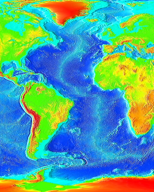
floors. In doing so, they had an even bigger surprise: the largest and longest
mountain range on Earth was – mostly – underwater. It was a continuous path
along the world’s seabeds, rather like the stitches on a cricket ball. If you began at
Iceland, you could follow it down the center of the Atlantic Ocean, around the
bottom of Africa, and across the Indian and Southern Oceans, below Australia;
there it turned across to the Pacific before shooting up the west coast of the
United States to Alaska. Occasionally its higher peaks rose above the water as
an island, like the Azores and Canaries in the Atlantic, Hawaii in the Pacific,
for instance – but mostly it was under thousands of feet of salty sea. The
network extended
to 46,600 miles.
 Then, in 1960, samples showed the ocean floor was quite young at
the mid-Atlantic ridge but grew older as you moved away from it. Harry Hess
considered the matter and realized that this could mean only one thing: new ocean
crust was being
formed on both sides of the central rift, then being pushed away
from it as new crust came along behind. The Atlantic floor was carrying crust
toward North America and Europe. The process became known as seafloor
spreading.
Then, in 1960, samples showed the ocean floor was quite young at
the mid-Atlantic ridge but grew older as you moved away from it. Harry Hess
considered the matter and realized that this could mean only one thing: new ocean
crust was being
formed on both sides of the central rift, then being pushed away
from it as new crust came along behind. The Atlantic floor was carrying crust
toward North America and Europe. The process became known as seafloor
spreading.
When the crust reached the end of its journey at the continents,
it dived back into the Earth in a process known as subduction. That explained
where all the sediment
went. It was being returned to Earth’s interior. It also explained why ocean
floors everywhere were so young. None was found to be older than about 175 million
years, which was odd because continental rocks were often billions of years
old. Now Hess could see why. Ocean rocks lasted only as long as it took them to
travel to shore. It was a beautiful theory that explained a great deal. Hess elaborated his
ideas in an important paper, which was ignored. Sometimes the world just isn’t ready for
a good idea.
It finally fell to two men from Cambridge University, a
geophysicist named Drummond Matthews and a graduate student, Fred Vine, to draw
all the strands
together. In 1963, using magnetic studies of the Atlantic Ocean floor, they
showed conclusively
that the seafloors were spreading in precisely the manner Hess had suggested and that
the continents were moving too.
Mobile crust was an idea whose time had finally come.
 Today we know that Earth’s surface is
made up of eight to twelve big plates and twenty or so smaller ones, and they
all move in different directions and at different speeds. Some plates are large
and inactive, others small but energetic. They have only an accidental
relationship to the landmasses that sit on them. The North American plate, for
instance, is much larger than the continent it’s associated with. Iceland is
split down the middle, which makes it tectonically half American and half
European. New Zealand, meanwhile, is part of the immense Indian Ocean plate
even though it is nowhere near the Indian Ocean. And so it goes for most
plates.
Today we know that Earth’s surface is
made up of eight to twelve big plates and twenty or so smaller ones, and they
all move in different directions and at different speeds. Some plates are large
and inactive, others small but energetic. They have only an accidental
relationship to the landmasses that sit on them. The North American plate, for
instance, is much larger than the continent it’s associated with. Iceland is
split down the middle, which makes it tectonically half American and half
European. New Zealand, meanwhile, is part of the immense Indian Ocean plate
even though it is nowhere near the Indian Ocean. And so it goes for most
plates.
The connections between modern landmasses and those of the past
were found to be much, much more complex than anyone had imagined. Kazakhstan,
it turns out, was once attached to Norway and the US. One corner of
Staten Island, but only a corner, is European. So is part of Newfoundland. Pick
up a pebble from a Massachusetts beach, and its nearest relative will now be in
Africa. Rocks, in short, get around.
The constant movement keeps the plates from fusing into a single immobile one.
If things continue as at present, the Atlantic Ocean will expand until eventually it is much
bigger than the Pacific. Much of California will float off and become an island
in the Pacific. Africa will push northward into Europe, pushing the Mediterranean
out of existence and throwing up a chain of mountains from Paris to Calcutta.
These are future outcomes, but not future events. The events are happening now.
As we sit here, we can see that Europe and North America are parting at about
the speed a fingernail grows —roughly two yards in a human lifetime. Look at a
globe and what you are seeing really is a snapshot of the continents as they
have been for just one-tenth of 1% of Earth’s history.
Alfred Wegener never lived to see his ideas proved right. On an expedition to Greenland in 1930, he set out alone, on his fiftieth birthday, to check out supplies. He never returned. He was found a few days later, frozen to death on the ice. He was buried on that spot and lies there now, but about a yard closer to North America than on the day he died.
If you want to watch some videos on this topic, you can click on the links to YouTube videos below.
If you want to answer questions on this article to test how much you understand, you can click on the green box: Finished Reading?
Videos :
2. Continental Drift 2 (11:00)
10. Vine and Matthews 2 (2:30)
11. Landmasses and Oceans (2:00)