
Disaster is a sudden adverse or unfortunate extreme event- natural or man-made, which causes great damage to human beings as well as plants and animals. It occurs rapidly, instantaneously, and indiscriminately that exceed the tolerable magnitude within given time limits, make human adjustment difficult, result in catastrophic losses of property, lives and income, and become the headlines of different news media at national and global levels. Natural disasters are those events or accidents that occur very rarely and aggravate environmental processes to cause human miseries. Natural disasters like floods, cyclones, storm surges, river bank erosions, droughts, etc. are occurring across the globe at an alarming rate, causing severe loss of human lives, crops, livestock, properties and physical infrastructure.
Introduction
Disaster is a sudden adverse or unfortunate extreme event- natural or man-made, which causes great damage to human beings as well as plants and animals. It occurs rapidly, instantaneously, and indiscriminately that exceed the tolerable magnitude within given time limits, make human adjustment difficult, result in catastrophic losses of property, lives and income, and become the headlines of different news media at national and global levels. Natural disasters are those events or accidents that occur very rarely and aggravate environmental processes to cause human miseries. Natural disasters like floods, cyclones, storm surges, river bank erosions, droughts, etc. are occurring across the globe at an alarming rate, causing severe loss of human lives, crops, livestock, properties and physical infrastructure.
This chapter devotes attention to natural disasters and
discusses some of the major environmental hazards experienced in the country or
elsewhere (e.g. tsunami, volcanic eruption etc.) highlighting their causes,
impacts on the environment, management, and measures for mitigation. The major
natural disaster that affects
A: Floods
Location
and Geographic Condition: Floods are
commonly labeled as unwanted inundation of land that can endanger people's
lives, their property, domestic animals, damage crops, homesteads and
infrastructure and disrupt economic activities. Indeed, floods are a recurrent
phenomenon in
Causes:
Floods in
·
heavy water flows
generated by intensive rainfall in the upland (upstream) catchment areas during
pre-monsoon period; 93 percent of the total catchment area lie across the
boarder;
·
excessive
siltation of the major river beds that have reduced their water carrying
capacity; (drainage congestion due to siltation of river beds)
·
a gentle slope gradient of the vast floodplain
that prevents quick recession of excess water;
·
huge water flows
produced by monsoon rain and consequent over spilling of the major rivers;
·
synchronization
of peak flows in the GBM river systems, causing drainage congestion at the
mouth (the Meghna confluence);
·
high tide in the
·
failure of runoff
that are produced by heavy local rainfall to quickly carry away water due to
high stage in the outfall rivers; and
·
storm surges due
to tropical cyclones in the
·
improper
structural development; and
· deforestation in upper catchment area
Types of Flood
In
Flash Floods: The normal sequence of floods in
Monsoon
Floods in the major rivers
(including their tributaries and distributaries) are characterized by slow rise
of water levels and gradual inundation of vast areas over several weeks through
over-bank spilling. These floods are mainly caused by snowmelt in the High
Himalayas, and intensive rainfall over the lofty ranges of the

Figure 16.1: An Image of
Monsoon Flood in
Rainwater
(Local) Floods: are caused
by long-duration, high intensity rainfall within
Storm Surges: Storm surges are raised sea levels caused by a combination low air pressure and strong onshore winds associated with tropical cyclones. In fact, tropical cyclones are often accompanied by storm surges- elevated sea levels, causing sudden but temporary flooding in the coastal areas, are responsible for most of the deaths and devastation. The extent of storm surge floods depends on a number of factors such as the peak of the storm surge at the coast, the relief of the adjoining land, presence of coastal embankment, obstruction of water flow by settlements, trees, crops and roads.
Extent, Trend and Impacts of Floods
Extent
and Trend:
Table 16.1: Extent of major flood and corresponding
damages in
|
Year |
Inundated
Area (sq. km) |
% of Area Inundated |
Damage (Million
Taka)
|
|
1954 |
36,778 |
25.55 |
1,200 |
|
1955 |
38,850 |
26.98 |
1,240 |
|
1956 |
35,883 |
24.64 |
2,180 |
|
1962 |
37,296 |
25.90 |
1,020 |
|
1963 |
35,224 |
24.46 |
83 |
|
1968 |
37,296 |
25.90 |
1,645 |
|
1970 |
36,260 |
25.18 |
330 |
|
1971 |
38,332 |
26.62 |
380 |
|
1974 |
38,850 |
26.98 |
10,000 |
|
1987 |
54,390 |
37.77 |
10,000 |
|
1988 |
43,994 |
58.33 |
50,000 |
|
1998 |
100,000 |
65.00 |
100.000 |
Source: Adapted through modification from Zohra, 1999 and Nishat et. al., 2001
The
three most damaging floods that occurred in
Environmental Impacts: Floods cause an enormous impact- negative and positive- on the national economy. Damage of crops, destruction of infrastructure, disruption of transportation, communication and livelihood (economic) systems, essential services, loss of livestock and other property, and occasionally some human lives are among the negative impacts of floods. Moreover, lack of access to safe drinking water and sanitation makes life difficult, often resulting in increased incidence of waterborne diseases. Among the positive impacts, an increase in subsequent crop production (bumper crops) due to better soil moisture, soil fertility and recharge effects of flooding, and enhancement of capture fisheries are noteworthy.
Flood Management and Mitigation
Flood
management and mitigation implies the use of conventional methods or measures
with an aim to avoid, prevent, minimize or reduce the impacts of disaster
caused by flood. Measures could be structural or non-structural or a
combination of both. The principal methods of structural and nonstructural
approaches used in
Structural
Methods
Embankments: In
Channel Improvement: Drainage congestion is the
result of silting up of river channels that reduces the conveyance capacity of
the rivers by making them shallower during the flood season. Good examples of
such rivers in southwestern
Pumped
Drainage: In flood prone areas some
control projects where gravity drainage is inadequate, pumped drainage is
provided such as
Flood Proofing: Flood proofing comprises of protection against flooding through a number of measures such as raising floors of homesteads, improving the quality (durability) of homestead walls, provision of storage facilities above the normal flood level, raising the levels of rural roads, market, schools, mosques, and other community centers, provision of boats or rafts for transport during flood time, small scale flood protection and drainage schemes with local community supports, and ensuring the use of public or government buildings as emergency shelters during severe floods. Flood proofing is cost effective and much more risk free solution than embankments> It has also least effect on hydrology and the environment.
Non-structural Measures
Flood Forecasting and Warning: Flood forecasting and warning is considered as one of the most effective non-structural methods for flood mitigation. The present flood forecasting and warning system of Bangladesh is consists of four main components: (a) a real time rainfall and water level data collection, (b) meteorological forecasting, (c) flood forecasting, and (d) flood warning and information dissemination. On the basis of real time observed data and the results of forecast models used, various bulletins are now issued, predicting the likely rise and fall of river stages at different locations. Currently, forecast on river level data is made at 44 locations inFlood Preparedness: As part of a broader disaster management strategy, flood preparedness
ensure the readiness and ability of the society to forecast floods and take
necessary precautionary actions in advance, and to develop response to cope and
adapt themselves with the changing circumstances (with the flood during its incidence
as well as to provide rescue, relief and other post-flood emergency
assistance). In
Floodplain
zoning: The ultimate objective of
floodplain zoning is to regulate the existing land use pattern in the area
concerned, in order to restrict or minimize damages, and also to avoid unwise,
undesirable or vulnerable uses of floodplains. Unfortunately, no definitive
model or framework has emerged in
Policy
Measures
After
the independence of
B: Cyclone
Introduction: Cyclone is another important natural hazard, which is
identified as a common feature of
How Tropical Cyclone does occur? Tropical cyclones are low pressure systems that develop in the tropics, in the southern hemisphere. Meteorologically, a tropical cyclone is a complex admixture of various weather elements such as vast rotating area of clouds, wind flows, thunderstorms etc. Tropical cyclones develop over warm seas near the equator. Air heated by the sun rises very swiftly, which creates areas of very low pressure. As the warm air rises, it becomes loaded with moisture which condenses into massive thunderclouds. Cool air rushes in to fill the void that is left, but because of constant rotation (turning) of the Earth on its axis, the air is bent inwards and then spirals upwards with great force. The swirling winds rotate very fast, forming a huge circle which can be up to 2,000 km across. At the centre of the storm is calm, cloudless, area called the eye, where there is no rain, and the winds are fairly light. The strongest winds and heaviest rains are found in the towering clouds which merge into a wall about 2030 km from the storms centre, Wind around the eye can reach speeds of up to 200 km/h, and a fully developed cyclone pumps out about two million tons of air per second. The cyclone aftermath includes heavy rainfall which causes direct damage to the community.
An Ideal Formation: An ideal condition for the formation and development of tropical cyclones includes a high sea surface temperature, high relative humidity in the lower troposphere, spiraling inflow of winds (convergence) at lower level, and outflow of winds (divergence) at upper level. In the northern hemisphere, winds surge around a centre in an anti-clockwise direction, while in the southern hemisphere it flows in a clockwise direction. Although the exact mechanism of formation is not known, typically the tropical cyclone originates as an easterly wave or weak low, which then intensifies and grows into a deep, circular low. It is presumed that the Inter-Tropical Convergence Zone (ITCZ), which lies near the equator and where wind blows from the opposite direction (two hemispheres), plays a vital role in the formation of the tropical cyclones High sea surface temperatures, over 27 Degree C (81 Degree F), are normally required for tropical cyclones to form.
Once formed, the storm moves westward in the beginning through the trade-wind belt, often intensifying as it travels. It then curves northwest, north, and gradually re-curves to move northeastwards, steered by westerly winds aloft. But this pattern of movement is not uniformly followed. Because of rapidly changing nature of the prevailing winds, tropical cyclones have developed a tendency to move erratically at times, causing abrupt changes in their direction.
Tropical
cyclones that affect
In the Indo-Bangla-Pak sub-continent, cyclones are classified according to their intensity of wind speeds. On this basis alone, three types of cyclones are identified in the region: (a) tropical depressions with maximum wind speed up to 62 km/hour; (b) tropical cyclonic storms characterized by thunderstorms and maximum sustained winds between 63 and 117/ km/hour; and severe tropical cyclonic storms (hurricane intensity) with sustained wind above 117 km/hour.
Nature
and Characteristics
The storm gains its energy primarily through the release of latent heat as the intense precipitation forms (the release of heat of condensation from water vapour at high altitudes). The storm's diameter may be 150 to 500 km (about 100 to 300 miles). Wind speed can range from 120 to 200 km (75 to 125 miles) per hour, and some times much higher. Barometric pressure in the storm center commonly falls to 950 mb or lower. An intense tropical cyclone is a circular storm centre of extremely low pressure, and because of the very strong pressure gradient, winds spiral inward at high speed. Convergence and uplift are intense, producing heavy rainfall.
A characteristic feature of tropical cyclone is its central eye- a relatively cloud and rain-free vortex (area/zone) with light winds, produced by the intense spiraling of the storm, and with a diameter of a few dozens of kilometers, in which clear skies and calm winds prevail. The eye of the cyclone is the centre of the cyclone where the focus lies. In the eye, air descends from high altitudes and is adiabatically warmed. As the cyclones builds up it begins to move, and sustained by a steady flow of warm, moist air. As the eye passes over a site, calm weather prevails, and the sky clears. Passage of the eye may take about half an hour (depending on speed), after which the storm strikes back with renewed ferocity, but with winds in the opposite direction. Wind speeds are highest along the cloud wall of the eye. The areas surrounding the eye is the most affected because of the strong wind
The most serious effect of tropical cyclones is usually coastal destruction accompanied by storm waves and very high tides. Since the air pressure at the eye of the cyclone is so low, sea level rises towards the centre of the storm. High winds create damaging surf and push water toward the coast, raising sea level further. Waves attack the sea shore at points far inland of the normal tide range. Low pressure, wind forces, and the underwater shape of a bay floor can combine to produce a sudden rise of water level known as storm surge, during which ships are lifted by the high waters and can be drawn far inland. Storm surge heights are directly related to cyclone intensity. If high tide accompanies the storm, the limits reached by inundation are even higher. This flooding can create enormous death tolls. Also important is the huge amount of rainfall produced by tropical cyclones, raising rivers and streams out of their banks. On steep slopes, soil saturation and high winds can topple trees and produce landslides and mudflows.
Effects
in
Table 16.2: Major Cyclonic
|
Year |
Date of Occurrence |
Maxm. wind speed (km/hr)
|
Storm Surge height (in feet) |
Affected Region |
Deaths |
|
1960 |
09-10
Oct |
200 |
10 |
Meghna
estuary |
3,000
|
|
1960 |
30-31
Oct. |
210 |
15-20 |
Meghna
estuary |
5,149 |
|
1963 |
28-29
May |
200 |
14-17 |
Chittagong-Cox’s
Bazar |
11,520 |
|
1965 |
11-12
May |
160 |
12 |
Barisal-Pautakhali |
19,270 |
|
1965 |
14-15
Dec |
210 |
15-20 |
Cox’s
Bazar |
873 |
|
1966 |
-01 Oct |
146 |
15-30 |
|
850 |
|
1970 |
12-13
Nov |
222 |
20-30 |
|
5,00,000 |
|
1974 |
24
-28 Nov |
162 |
7-16 |
Chittagong-Cox’s
Bazar |
A
few |
|
1985 |
24-25
May |
154 |
10-15 |
Noakhali-
Chittagong |
11,069 |
|
1988 |
-29 Nov |
162 |
5-10 |
|
2,000 |
|
1991 |
-29 Apr |
225 |
20-25 |
Noakhali-Chittagong |
1,40,000 |
|
1994 |
-02 May |
210 |
15-20 |
Chittagong-Cox’s
Bazar |
170 |
|
1997 |
-19 May |
220 |
15-20 |
Noakhali-Chittagong |
126 |
|
1998 |
-19 May |
150 |
10
|
Noakhali-Chittagong |
03 |
|
2007 |
15-16
Nov |
223 |
15-20 |
|
- |
Source: Compiled by the author from a number of sources- Rasheed, 2008; Chowdhury, 2001; UNEP, 2001; MES 1999.
The
above Table (16.2) lists some of the major cyclones that affected
Management: Mitigating Cyclones
Cyclone
Forecasting: One of the most
important aspects of tropical cyclone is that it is distinct from all other
natural hazards because of its worldwide ability of early warning systems (satellite images, radars, computers
etc.) as a basis for disaster preparedness and mitigation.
C: River Bank Erosion
River bank erosion is a
regular and recurring phenomenon and is also one of the most serious natural
disasters in
to
bank failure. River bank erosion is rapid on the outer circumference of the
channel meanders, while deposition occurs on the inside loop. However, sudden
changes take place during high floods causing severe erosion. Satellite images
of the GBM rivers demonstrate varying degrees of bank erosion and accretion in
different years with an estimated erosion rate of nearly 9,000 ha of land. The
braided Brahmaputra-Jamuna river is regarded as the most vulnerable rivers to
bank erosion on both of its banks. According to EGIS estimate (2000) , the rate
of widening of the Jamuna river between 1973 and 2000 was 128 m/year (68 meter
for the left bank and 60 meter fo the right bank). This has resulted in a loss
of floodplain area of 70,000 ha over 220 km length of the river in
Management: Erosion management is not
only difficult but an expensive task. For a densely populated country like
D: Drought
Drought-
a climatological phenomenon- characterized by inadequate water supply to meet
the normal requirements for agriculture, livestock, fisheries, industry and
domestic uses. Drought occurs when there is a lack of sufficient water or less
than optimum rainfall for a prolonged period, resulting in marked hydrological
imbalances, leading to parching of the ground, soil moisture stress, withering
of vegetation, and depletion of groundwater as well as decrease of stream flow
and fluctuation of ground water table. Although generally occur in arid and
semiarid regions of the world, drought incidence can also be found in certain
areas of the humid tropics that normally experience sufficient annual rainfall
with high seasonal variability. Under such conditions, evaporation and
evapo-transpiration exceeds normal levels if prolonged, which might severely
affect agricultural production. In
promote
agricultural research and extension works; intensive afforestation projects; re-excavation
of channels and ponds in rural areas; augmentation of surface water flow and
construction of water reservoirs.
E: Earthquake
An earthquake is a form of energy of wave motion transmitted through the surface layer of the earth in widening circles from a point of sudden energy release- the 'focus' (the place of origin of an earthquake, the depth of which varies from place to place- 20 km to 700 km below the earth’s surface). The place on the ground surface, which is perpendicular to the ‘focus’, recording the seismic waves for the first time is called ‘epicentre’. The seismic waves move away from the source of the earthquake (focus) in the form of (i) primary or pressure/ P waves; (ii) secondary, shear or transverse/ S waves; and (iii) tertiary, long or surface/ L waves. These seismic waves that are recorded (Seismograph) with the help of an instrument are called Seismometer. The magnitude or intensity of energy released by an earthquake is usually measured by the Richter scale (ranges between 0 and 9), devised by Charles F. Richter in 1935. When the patterns of recorded seismic waves are studied various information about the focus of the earthquake, its magnitude, destructive power, and probable cause can be identified. A number of reasons that have been assigned to cause disequilibrium in the earth's crust are volcanic eruption, faulting and folding, hydrostatic pressure of mad-made water bodies like lakes and reservoirs, and of late the plate movements. As such, an earthquake is a major demonstration of the power of the tectonic forces caused by endogenetic thermal conditions of the interior of the earth.
In
More
than 100 earthquakes (moderate to large) occurred in

Figure
16.2: Seismic Zoning Map of
Impacts: The shocks produced by earthquakes cause slope instability and slop failure leading to landslides and debris falls which damage settlements and transport systems on the down slope segments in hilly areas Earthquake also inflict great damage to human structures such as buildings, roads, factories, dams, bridges and thus cause heavy loss of human property. The destructiveness of an earthquake is determined on the
basis of human casualties in terms of death. The most recent earthquakes that caused significant damages to life and property are Sylhet earthquake (May 8, 1997), Bandarban earthquake (November 21, 1997), and Moheshkhali earthquake (July 22, 1999).
Management
In
F: Landslides
The Earth’s land moves at least a few centimeters a year. But there are times when it can move meters or even kilometers at a time. This is when there is a landslide, avalanches or mudflows. Landslide is a geological phenomenon, caused by changes in the stability of a slope and includes sudden downward movement of large mass of soil and rock material due to gravity: e.g. rock falls, mud falls, shallow debris flows and deep failure of slopes. Landslides typically occur at the head of valleys in steeply-sloping hill areas. They can also occur alongside rivers and streams. They can vary in size and can be as small as the movement of a single boulder in a minor rock fall or as big as thousands of tones of earth and debris that fall to the bottom of a slope or a cliff. As the land slowly moves, by a few millimeters a day, it causes tension cracks in the earth and in the bedrock. As this tension increases and significant changes in moisture occur, from things like heavy rainfall or the fast melting of snow, the land begins to move more and more. The image below (Figure 16.2) shows how this movement in the land can cause a landslide.

Effects of landslides and issues: Landslides can happen in different places and have
different effects on people, buildings, animals and landscape. In
Causes: Physical
causes responsible for such movements are topography,
weakening of slopes through saturation by water, steepening of slopes by erosion, alternate freezing or thawing, earthquakes, volcanic eruptions, storms, and forest fires. Among anthropogenic causes, deforestation, loss or absence of vertical vegetative structure, steepening
of slopes by human modification,, vibrations
from machinery
or traffic,
blasting, construction, agricultural, or
forestry activities are notable. Among the agents of change that are identified
in the context of
Management: A ‘Geophysical Analysis’ should be carried out by the experts compromising Geographers, Geologists, Engineers, Environmentalists, City planners etc. groups and the extent of the damage should be calculated. Experts may also suggest ways to prevent the further damage and recovery, if any, from the damage already done. A number of steps can be taken as follows:
·
Proper investigation of
the causes of landslide is essential;
·
Land-use zoning and
identification of hilly areas as shown on cadastral map is required;
·
Preparation of special
land use policy is needed based on site plot information;
·
Professional
inspections and proper design can minimize many landslide problems;
·
Hill cutting should be
totally stopped;
·
No agricultural cultivation
should be allowed on hills;
·
Proper plantation of
trees and creation of green belts on hills should be encouraged;
·
Quick drainage of
rainwater is very essential to reduce vulnerability to landslides;
·
The Government should
ban all human habitation in vulnerable foothill areas;
·
Setting up of slums on the
sides of vulnerable hills should also be stopped;
·
The
most vulnerable areas at the foothills should be red-marked and settlements in
those areas should be evacuated;
·
A strong enquiry team
is to be formed to look into matter to find the offenders;
·
Only punishment to
the criminals whoever he may be will protect hills and the environment in
future; and
·
The
local administration should be more active and people's awareness must be
raised to avoid repetition of such incident in future.
G: Tsunami
What is a tsunami?
The
phenomenon we call "tsunami" (soo-NAH-mee) is a Japanese word. The
English translation is "harbor wave." Represented by two characters,
the top character, "tsu," means harbor, while the bottom character,
"nami," means "wave." In fact, a tsunami consists of a
series of waves. Often the first wave may not be the largest. The danger from a
tsunami can last for several hours after the arrival of the first wave. In the past, tsunamis were sometimes incorrectly
referred to as "tidal waves" by the general public and as
"seismic sea waves" by the scientific community. The term "tidal
wave" is a misnomer; although a tsunami's impact upon a coastline is
dependent upon the tidal level at the time a tsunami strikes, tsunamis are
unrelated to the tides. Tides result from the imbalanced, extraterrestrial,
gravitational influences of the moon, sun, and planets. The term "seismic
sea wave" is also misleading. "Seismic" implies an
earthquake-related generation mechanism, but a tsunami can also be caused by
any non-seismic events such as underwater volcanic eruptions,
landslides, explosions, and even the impact of cosmic bodies such as
meteorites. Now, tsunami is defined as a series of traveling ocean waves of
extremely long length, generated by disturbances associated primarily with
earthquakes.
What
cause tsunamis?
Not all earthquakes generate tsunami, but the tectonic one. To generate tsunamis, earthquakes must occur underneath or near the ocean floor, be large enough and create movements in the sea floor. Tectonic earthquakes are a particular kind of earthquake that are associated with the earth's crustal deformation; when these earthquakes occur beneath the sea, the water above the deformed area is displaced from its equilibrium position. Waves are formed as the displaced water mass, which acts under the influence of gravity, attempts to regain its equilibrium. When large areas of the sea floor elevate or subside, a tsunami can be created. In other words, tsunamis can be generated when the sea floor abruptly deforms and vertically displaces the overlying water column (disturbed by the uplift or subsidence of the sea floor).
The
continents and sea floor that cover the earth's surface are part of a
world-wide system of plates that are in motion. These motions are very slow,
only an inch or two per year. Large vertical movements of the earth's crust can
occur at plate boundaries. Earthquakes occur where the edges of plates run into
one another. Such edges are called fault lines or faults. Sometimes the forces
along faults can build-up over long periods of time so that when the rocks
finally break an earthquake occurs. Examples of features produced by forces
released along plate edge faults are the
Wave height and water depth
Tsunamis are unlike wind-generated waves, which many
of us may have observed on a local lake or at a coastal beach, in that they are
characterized as shallow-water waves. In
the deep ocean, their length from wave crest to wave crest may be a hundred
miles or more but with a wave height of only a few feet or less. In the deep ocean, destructive tsunamis can
be small--often only a few feet or less in height--and cannot be seen nor can
they be felt by ships. In deep water, however, the tsunamis propagate at high speeds, (may reach
speeds exceeding 500 miles per hour) and also can travel great, transoceanic distances with limited energy losses.
Tsunamis wave energy extends from the surface to the bottom in the deepest
waters. Where the ocean is over 20,000
feet deep, unnoticed tsunami waves can travel at the speed of a commercial jet
plane, nearly 700 miles per hour. They can move from one side of the
As the tsunami leaves the deep water of the open ocean and travels into the shallower water near the coast, it transforms- wave height can increase rapidly. A typical tsunami travels at a speed that is related to the water depth - hence, as the water depth decreases, the tsunami slows. The tsunami's energy flux, which is dependent on both its wave speed and wave height, remains nearly constant. Consequently, as the tsunami's speed diminishes as it travels into shallower water, its height grows. Because of this shoaling effect, a tsunami, imperceptible at sea, may grow to be several meters or more in height near the coast. When it finally reaches the coast, a tsunami may appear as a rapidly rising or falling tide, a series of breaking waves, or even a bore. It can move faster than a person can run. Large tsunamis have been known to rise over 100 feet, while tsunamis 10 to 20 feet high can be very destructive. All low lying coastal areas can be struck by tsunamis. As the tsunami attacks the coastline, the wave energy is compressed into a much shorter distance creating devastating, live-threatening waves. Sometimes, coastal waters are drawn out into the ocean just before the tsunami strikes. When this occurs, more shoreline may be exposed than even at the lowest tide. This major withdrawal of the sea should be taken as a warning of the tsunami waves that will follow.
Where tsunamis occur?
All oceanic regions of the world can experience
tsunamis, but it is in the
Pacific-wide
and local tsunamis: Tsunamis
have great erosional potential, stripping beaches of sand that may have taken
years to accumulate and undermining trees and other coastal vegetation. Capable
of inundating, or flooding, hundreds of meters inland past the typical
high-water level, the fast-moving water associated with the inundating tsunami
can crush homes and other coastal structures. Tsunamis may reach a maximum
vertical height onshore above sea level, often called a runup height, of 10,
20, and even 30 meters. Tsunamis
are a threat which can savagely attack coastlines, causing devastating property
damage and loss of life to anyone living near the ocean. The 1960 Chile Earthquake generated a Pacific-wide tsunami
that caused widespread death and destruction in
Case
Study: The Powerful
The 2011 earthquake off the Pacific coast of Tōhoku also known as the 2011 Tohoku earthquake, the Great East Japan Earthquake, was a
magnitude 9.0 (Mw) undersea megathrust earthquake off the coast of Japan that
occurred at 14:46 on Friday, 11 March 2011, with the epicenter approximately 70
kilometres (43 mi) east of the Oshika Peninsula of Tōhoku and the hypocenter at
an underwater depth of approximately 32 km (20 mi). It was the most powerful
known earthquake ever to have hit
The tsunami caused a number
of nuclear accidents, primarily the ongoing level 7 meltdowns at three reactors
in the Fukushima Daiichi Nuclear Power Plant complex, and the associated
evacuation zones affecting hundreds of thousands of residents. Many electrical
generators were taken down, and at least three nuclear reactors suffered
explosions due to hydrogen gas that had built up within their outer containment
buildings after cooling system failure. Residents within a 20 km (12 mi) radius
of the Fukushima Daiichi Nuclear Power Plant and a 10 km (6.2 mi) radius of the
Fukushima Daini Nuclear Power Plant were evacuated. In addition, the
On 12 March 2012, a Japanese
National Police Agency report confirmed 15,854 deaths, 26,992 injured, and
3,155 people missing across twenty prefectures, as well as 129,225 buildings
totally collapsed, with a further 254,204 buildings 'half collapsed', and
another 691,766 buildings partially damaged. The earthquake and tsunami also
caused extensive and severe structural damage in north-eastern

Figure 16.3: Aerial photo of Minato,
devastated by the tsunami: Source: Wikipedia

Figure 16.4: Damaged utility pole in Ishinomaki by the tsunami, Source: Wikipedia
Prediction: Since scientists cannot
predict when earthquakes will occur, they cannot determine exactly when a
tsunami will be generated. However, by looking at past historical tsunamis,
scientists know where tsunamis are most likely to be generated. Past tsunami
height measurements are useful in predicting future tsunami impact and flooding
limits at specific coastal locations and communities. Historical tsunami
research may prove helpful in analyzing the frequency of occurrence of tsunamis
and their relationship to large earthquakes. The Tsunami Warning System (TWS)
in the Pacific, comprised of 26 participating international Member States,
monitors seismological and tidal stations throughout the
H: Volcanic Eruption
What is Volcanic Eruption?
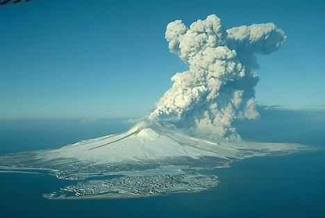
A volcano can be simply defined as an opening on the Earth crust. This opening allows hot ash, molten rock and gases to blow off from the underground spaces. Volcanoes generally acquire shape of a mountain. Volcanoes are usually found at places where tectonic plates get converged or diverged. But there existence at a particular place depends upon many environmental and geological factors. Volcanoes can also occur at a place because of hot spots or mantle plumes. Even hotspot volcanoes are very common at other planets of solar system especially on moons and rock based planets.

Figure
16.5: An Image of a Typical Submarine Volcanic Eruption
Features of Volcanoes
Common features of volcanoes
are lava, conical shaped mountain and release of poisonous gases from the
carter situated at the summit of the volcanoes. These are most common features
attained by almost all of the active volcanoes. Material erupted by a volcano
is called as lava. Lava is just a name given to magma,
once it gets erupted from the mouth of volcano. But describing complete features of all the volcanoes is a very tedious thing, because shape, attributes and behavior of different volcanoes depends upon different factors.
Submarine volcanoes- These are the volcanoes which are
located at the floors of oceans (Figure 16.5). They can be at lower or extreme
depths. Those volcanoes which are present at lower depths produce bubbles of
steam and gases, which can be observed above the sea surface. But other
volcanoes which are present at extreme depths are almost invisible about their
existence. But even these deep volcanoes can also be marked by observing
discoloring of water at a particular portion of ocean. This discoloration is
because of release of volcanic gases in the sea. Other less common types of
volcanoes are sub glacial volcanoes,
Volcanoes on basis of Activities
On basis of activities volcanoes are classified into three types: active, dormant and extinct. Those volcanoes which are showing eruption regularly are called active volcanoes. A volcano can be simply considered as active one if in current times it is showing eruptions or simply acting restless. Dormant- Those volcanoes which have previous record of eruption in historical times but which are quite from many years are considered as dormant volcanoes. Extinct- Those volcanoes about which no previous record of eruption is available and which are quite in current times also are considered as extinct volcanoes. In other words, these are simply those volcanoes about which it has been already postulated that they will not erupt again, because they have no current connections for supply of lava. So these rae simply non-erupting dead volcanoes.
Effects of Volcanic Eruptions
Different volcanic eruptions produce different sort of effects on environment and society. General eruption contains gases like water vapors, SO2, HF, CO2, HCl and ashes of melted rocks. Explosive eruptions supply these materials directly to the stratosphere at the heights of 16–32 kms. Now in stratosphere SO2 gets converted into H2SO4, this H2SO4 gets condensed into the sulfate aerosols. Accumulation of sulfate aerosols in earth’s atmosphere increases its reflection for the rays of sun; as a result temperature gets decreased in lower layer of atmosphere called troposphere, but due to accumulation of aerosols in stratosphere, temperature gets increased here. This temperature cuts and fluctuations produce large effects on overall earth’s temperature. Accumulation of sulfate aerosols also causes chemical reactions which eventually cause destruction of protective ozone layer of earth’s atmosphere. Acid rain is also a common effect of volcanic eruptions. Moreover when a volcanic eruptions occurs the flow of lava destroy all the surrounding crops of the region and people need to migrate from that zone because flow of lava destroy each and each every thing coming on its way. Ash and rain of molten rocks are other effects of volcanic eruptions.
Disaster
Management
Disaster management is an applied science- a special
type of emergency management- which seeks to improve measures relating to
prevention, mitigation, preparedness, emergency response and recovery by the
systematic observation and analysis of disaster. In
Disaster Preparedness is the most important phase of the whole process of Disaster Management. It includes forecasting and taking precautionary measures prior to an eminent threat. It also includes the formulation of a viable counter disaster plan, maintenance of inventories of resources and the training of the personnel. Disaster preparedness minimizes minimizes the loss of an extreme event through effective readiness measures to expedite emergency action, rehabilitation and recovery, ensuring the timely, appropriate and efficient delivery of relief and emergency assistance following a disaster.
Disaster Response may be defined as the sum total of actions taken by the mass and the institutions in the face of a disaster. It includes the implementation of Disaster Preparedness Plans and Procedures, and also the completion of disaster rehabilitation program. The activities of disaster response cycle could be
exhaustive, but essentially involves warning, evacuation, search and rescue, post disaster assessment, emergency relief, logistic and supply, information and communication, survivor response and coping, security, rehabilitation and reconstruction.
Disaster Mitigation means risk reduction which can be classified in a number of ways: active and passive; structural and non-structural; restrictive and incentive; Spatial and sector based. It encompasses all actions taken prior to the occurrences of a disaster including long-term reduction and preparedness measures. Mitigation tries to lessen the impact of disaster by improving the community’s ability to absorb the shock of with minimum damage, loss disruptive effect. Mitigation applies to measures such as structural engineering projects, spatial planning, economic planning, institutional management, conflict minimization and societal action.
Organizational Arrangement of
Key Bodies in
The most difficult of part of disaster management is
the availability of correct data for disaster planning and mitigation. Loss and
damage reports are often exaggerated that these data make disaster related
planning complex. Despite the fact,
National Disaster Management Council (NDMC): Responsible for establishing policies and providing overall direction for all aspects of disaster management; also define priorities and criteria for the allocation of resources.
Inter
Ministerial Disaster Management Co-ordination Committee (IMDMCC)
Implement NDMC policies and provide direction on an inter-ministerial basis. Coordinate actions taken by all governmental bodies and direct activities of the DMB. Responsible for major operational decisions during an emergency; make decisions on allocation of relief materials.
National
Disaster management Advisory Committee (NDMAC)
Provide advice to the NDMC and directly to the MDMR and DMB on technical and socio-economic aspects of disaster management.
Ministry
of Disaster Management and Relief (MDMR)
Responsible for disaster management at the ministerial level including the convening of the NDMC and IMDNCC; ensuring the efficient functioning of DMB (resource, budget etc.)
Disaster
Management Bureau (DMB)
DMB) is a concise dynamic professional unit at national level working in close collaboration with the District and Thana level authorities and the concerned line ministries (under the overall authority of IMDMCC) to perform specialists functions. DMB is a part of MDMR which ensures provision of expert staff services to the NDMC and IMDMCC. It promotes disaster preparedness including prevention and mitigation at all levels of government and agencies. It also provides guidelines, organize training, and promote the preparation of disaster plans.
Directorate
General of Relief and Rehabilitation (DRR)
Responsible for management and delivery of relief supplies including the provision of related services.
NGO
Involvement in Disaster Management
Besides government, some NGOs are also involved in
disaster management activities (rescue, relief, rehabilitation, disaster
related training and public awareness building) in